


Mont St Jacques depuis plan bois (aller)

Robertplessier
User
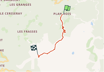

Length
4.1 km

Max alt
2395 m

Uphill gradient
557 m
Km-Effort
9.6 km

Min alt
1835 m

Downhill gradient
6 m
Boucle
No
Creation date :
2024-08-07 09:46:36.461
Updated on :
2024-08-07 10:53:49.998
1h07
Difficulty : Medium

FREE GPS app for hiking
 SityTrail
IGN / Geographical institutes
SityTrail Plus
The world is yours!
About
Trail Walking of 4.1 km to be discovered at Auvergne-Rhône-Alpes, Savoy, La Plagne-Tarentaise. This trail is proposed by Robertplessier.
Description
Superbe!
Positioning
Country:
France
Region :
Auvergne-Rhône-Alpes
Department/Province :
Savoy
Municipality :
La Plagne-Tarentaise
Location:
Mâcot-la-Plagne
Start:(Dec)
Start:(UTM)
321698 ; 5045402 (32T) N.
Comments